Arizona > Havasu Falls > Havasu Falls Hiking Map
Hiking To Havasu Falls:
Location: Supai, Arizona
Cost: $35 Hiking Pass
Start: Hilltop Parking Lot (End of Route 18, 61 miles from Route 66)
End: Havasu Falls (11 Mile Hike, Helicopter Ride, or Mule Ride)
Time Needed: 1-2 Full Days
Prohibited Items: Dogs, Firearms, Drugs, Alcohol
Fun Scale: 10 out of 10
(Printable Map 1 | Map 2)
Hike Overview:
Hiking to the different waterfalls of Havasu Falls is an awesome and rewarding experience. Located in the remote village of Supai Arizona, the turquoise waters of the Havasupai Indian Reservation create some of the best secluded waterfalls you’ll find anywhere. How secluded? Not only does it take over a 10-mile hike into the canyon to get to the falls, but the tiny village of Supai is the only city in America where the U.S. Postal Service still delivers mail by horseback.
Sitting between the Grand Canyon National Park and Las Vegas, we highly recommend the Havasu Falls as the closest thing to a fairytale oasis we’ve found. The water will be chilly and the hike will be long, but it is well worth it. Make sure the print off our maps just in case your cell phone service doesn’t work.
Hiking Distances From Hilltop (In Miles)
Wash Basin 1.5; Havasu Basin 6.2; Supai Village 7.1; Rock/Navajo Falls 8.7; Havasu Falls 9.5; Campground 10; Mooney Falls 10.8; Beaver Falls 13; Colorado River 19
Sights On The Havasu Falls Hike:
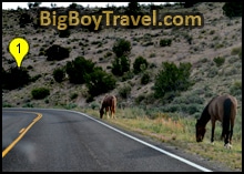
1. Route 18 Drive:
2. Hilltop Parking Lot:
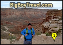
As mentioned above, it takes 2 hours off of Route 66 to get to the Hill Top Parking Lot. In total, the Hilltop is 4 hours from the Grand Canyon Visitor Station, 4.5 hours from Las Vegas, and 5 hours from Phoenix. Because the hike is long and the Summer heat is in the 100’s mid-day, you need to make sure yo get here early to start your hike and if you are going roundtrip in one day you need to start around sunrise.
3. Switchback Trail:
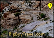
Section Distance Hiked: 1.5 Miles, takes around 30 minutes without stops.
4. The Wash Basin Hike:
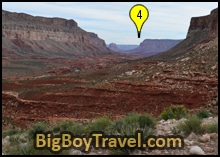
From the beginning of the basin to the end, it is roughly 4.5 miles and you’ll pass through a bunch of great sights to take in. In addition to the large number of pack horses you’ll cross you’re bound to see several wild horses and even some long horn sheep at the start of the Basin. Remember that these animals are wild and you should always keep a safe distance. Just over 1 mile into your hike the Basin will start to narrow quite a bit which will block some sunlight giving you some much-needed shade. It is at about the same point that cool rock overhang caves will start to pop up and even sections of Reef Rock which is a formation of deeply tilted layers of sandstone.
Section Distance Hiked: 4.7 Miles, takes around 90 minutes without stops.
5. The Havasu Basin:
While crossing the wide bridge over the river you’ll be amazed at how crystal clear the turquoise-tinted water is. The water is worth a closer look as the cool shallow stream is bound to be your first time seeing water this water. The turquoise color comes from the high concentration of dissolved lime the water picks up from the sedimentary rock of the canyon. The unique color seems to get even richer the deeper it gets.
Section Distance Hiked: 1 Mile, takes around 20 minutes
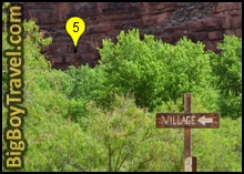
6. Supai Village:
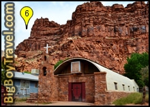
The entire village is about a mile long and right in the middle of it you’ll have to stop by the Campground and Hiking Office. This is where you will pay for your hiking pass and if you have a balance to pay for camping they will also give you your bag tags. Just past the office is a quaint school plus a very handy General Store where you can buy snacks and drinks. We always side on bringing enough food and water in case the store isn’t open as it can be very dangerous to hike so far unprepared, but we’ve never seen the store closed. Because Supai is the only city in the United States to still get their mail by Pony Express the post office is a very unique place to send a postcard back home. If you are wondering where the Hotel is, it is only a short walk behind the cute little stone church.
Section Distance Hiked: 1 Mile, takes around 20 minutes
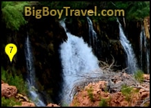
7. Navajo & Rock Falls:
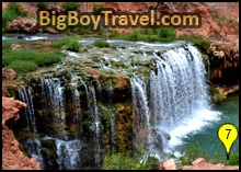
If you’ve ever dreamed about finding a secret passageway behind a waterfall this is your chance. Hugging the far side of Rock Falls there is a very easy-to-navigate path that goes right behind the water into a protected rock shelf cave. Although it is fairly safe, like any water areas watch your step on the slippy rocks and consider wearing sticky water shoes. If you are brave you can even jump through the falls and canyon ball into the swimming pool, just double-check for boulders first.
Section Distance Hiked: 1.5 Mile, takes around 30 minutes
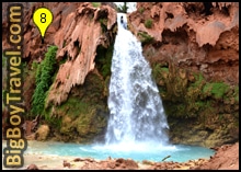
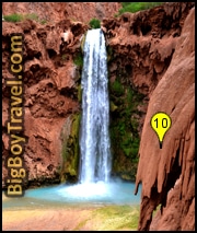
8. Havasu Falls:
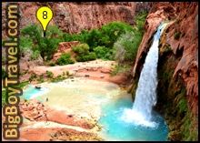
As you finally make your way down to the picnic area are the base of Havasu Falls we suggest resting on a bench for a few minutes just to be able to take is the size and strength of the Falls. The large red rock wall Havasu Falls bursts out of is covered in Gothic-looking stalactite fingers which help to enhance the fall’s power. This entire wall was a 200-wide waterfall until flooding in 1910 carved out the current path and consolidated the flow. The same flood that formed Rock Falls in 2008 also altered Havasau Falls by busting out part of the rock shelf reducing the height of the Falls by almost 40 feet. Don’t worry though, even with a shave off the top, the Falls are huge and still about as tall as Niagara Falls in New York.
Section Distance Hiked: 1 Mile, takes around 20 minutes
9. Havasu Campground:
About Havasu Campground: Even if you aren’t staying overnight at the campground, it is awesome to walk through. The water here is fairly shallow and is easy to navigate with a series of makeshift, but sturdy wooden bridges. Although the campground is very shaded by trees, many campers still go the extra to cool off and plop their picnic table right into the thigh-high water and pop a squat.
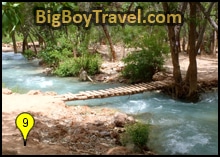
At the end of the Campground is a very nice set of raised bathrooms which are a welcomed addition to the Falls area. Although they don’t have water, the stalls are private and spacious so you have a place to change clothes if you are only day hiking instead of staying overnight. If you are camping, be grateful you won’t have to poop outside anymore.
Section Distance Hiked: 1/2 Mile, takes around 10-15 minutes
10. Mooney Falls:
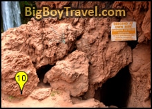
To get a closer look at Mooney Falls you will head into a series of natural tunnel caves with steps cut in them to start your further descent. The tunnels are a little cramped and you have to watch your step, but it is very manageable. As you pop out of the first tunnel you have a small viewpoint a couple hundred feet above the canyon floor with only a short sketchy chain as a guardrail. We find climbing in the caves to be very safe and fun, it’s just the next part as you head out of the second cave that is a little tricky.
Coming out of the second tunnel, everything really opens up and the path becomes a bunch of tall narrow steps with only a loose chain to hold on to. The easiest, and by far safest, way to navigate this stretch is to go down slowly and backward. As long as you regroup before you start and take your time on the way down it isn’t that bad, just double-check the holds of the chain if you are using it on the way down. For the most part, the chain is fine, but it can be loose on some steps so checking first is always good. The steps end about 12-15 feet shy of the bottom and you do the last part with an oversized ladder. It is nice the ladder is big and wide, but for whatever reason the rungs always seem spaced out too far from one another.
Section Distance Hiked: 1 Mile, takes around 20 minutes
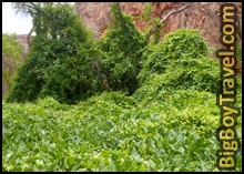
11. Valley Of The Vines:
12. Beaver Falls:
About Beaver Falls: These falls are very tricky to hike to as not only are they over 2 miles past Mooney Falls, but they require fording the river a few times and using a questionable rope to get past a rock ledge. Tons of people make it all the way here, but if you are day hiking don’t even consider it and just turn around at Mooney Falls instead. You should only attempt to go this far if you are staying overnight here. If you are well rested the last couple miles to Beaver Falls is very manageable and you are rewarded with a cascading series of mini-waterfalls up to 8 feet in height. In the grand scheme of things the calcium carbonate pools at Mooney Falls are probably more interesting though and will save you an extra 6-mile roundtrip hike.
Section Distance Hiked: 2.5 Miles, takes around 60-70 minutes
13. Havasu Rapids At The Colorado River:
About Havasu Rapids At The Colorado River: If you have made it to the Colorado River you are a true wild person as it is a boggling 19 miles each way from the Hill Top Parking Lot. The turquoise waters of Havasu make a defined color line as it mixes with the brown waters of the Colorado which is a contrast very popular with photographers. It is possible to hike the entire way especially if you are staying a couple nights in the campground, but most visitors only get to the rolling rapids if they are on a Colorado Rafting trip. Some of the best rafting trips will let you branch off the Colorado by kayak as the last couple miles of the Havasu waters are the brightest turquoise color.
Section Distance Hiked: 6 Miles, takes around 2-2.5 hours


