Free Paris Walking Tour:
Walking Tour Location: Latin Quarter & Île de la Cité
Style: Do-It-Yourself Walking Tour (Self-Guided)
Start: Parvis De Notre Dame
End: Pont Neuf Bridge
Walking Distance: 2 Miles
Time: 1.5 Hours for Walk (with attractions 5-6 hours)
Fun Scale: 10 out of 10
Overview of the Latin Quarter:
Our free Paris walking tour focuses on historic Latin Quarter and Île de la Cité which make up the true heart of the city. With pre-historic roots, the area around greater Paris was settled by the Parisii tribe in the 3rd Century BC. In 52BC, the Parisii joined other Celtic tribes to defend Gaul (France, Belgium, & Switzerland) from a Roman takeover which they lost. The Romans quickly laid out the town of Lutèce (Lutetia) on the South side of the Seine River complete with a forum and 15,000 seat amphitheater. In 20 AD local sailors erect the Pillar of the Boatmen in honor of the Roman god Jupiter on the central island where Notre Dame sits today. Area in 40AD, Forum & Baths in 100AD. Grew to pop of 8000, named after the Marsh on the North side. In 280 AD, Lutèce was sacked by Alaman Tribe (Germanic Barbarians) invaders and the remaining citizens moved to the more easily to defend the central island. The region remained part of the Roman Empire, was 313 A.D. Emperor Constantine legalized Christianity, re-named Paris in 360. In 451 the Huns threaten, but attack Tours instead and are then defeated by local forces after Saint Genevieve convinced the locals not to flee. Pop before the Romans was 25,000, during 80,000, then down to 30,000, down to 20,000 after Vikings, Between 1170 and 1220, the population of the city doubled, from 25,000 to 50,000; 160,000 by 1250 and 300,000 by the 1300s
In 464 Paris is blockaded by the Franks and Paris surrendered to them. After the Western Roman Empire started to fall, the Franks overtook much of modern-day France and King Clovis made Paris their capital in 508. In 540 Construction of the Saint-Étienne cathedral, the predecessor to Notre Dame begins. King Charlemagne becomes the first Holy Roman Emperor in 800AD. Mid to late 800s, Vikings siege Paris multiple times until Charles the Bad builds two bridges to blockade their ships along with new fortifications and palace. Notre Dame built in a Gothic style from 1163 to 1345. In 1197 flooding makes the King leave the palace for Saint Genevieve Hill until a new Palace is built from 1296-1314.
Louvre fortress built from 1190-1202 like a castle with a moat and added on to for 200 years until it was tore down in 1546 in favor of a traditional French Palace. Francis I had it to look like Palace of Fontainebleau where he was born. The 2 large wings added by Napoleon III in the 1850s. Part opened as a museum in 1794, with the rest after. Remains of the medieval foundations can still be seen on the lower ground floor of the Sully wing. Sainte Chapelle (which contained the remains of the True Cross) was completed in 1248 and Crown of Thorns said to be placed here during construction. 1415 English over took France until Joan of Arch took it back in the mi-1400s.
In 1450 the wolves of Paris were trapping inside Notre Dame and killed. Had grown to the largest city in the Western world in the Middle Ages and by 1550 was the biggest in the world (cite, pop in 1204 was 200,000 and 250,000-300,000 in 1328 which was the 1st census which counted homes). 1558: Mary, Queen of Scots is married to the Dauphin Francis (later Francis II of France), son of Henry II of France.
coronation of Napoleon I and his wife Joséphine, with Pope Pius VII officiating on 2 December 1804 at Notre-Dame. 1831: The novel The Hunchback of Notre-Dame was published by French author Victor Hugo, Les Mis in 1862. In the 1860s, the boulevards and streets of Paris were illuminated by 56,000 gas lamps.
We hope you enjoy our free Paris walking tour!
Free Paris Walking Tour:
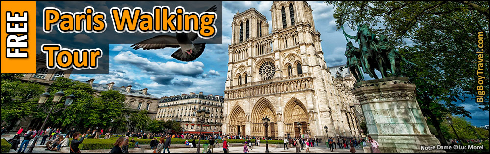
1. Notre-Dame Cathedral:
About Notre Dame Cathedral: Also known as Notre-Dame de Paris, the former location of a Roman temple and then the Basicilia of Saint Stephen (Saint-Étienne) which dated back to either the 4th or 7th (renovation of rebuild) century until 1160. This early 5-nave basilica was very large for its time and around half the total size of the current Cathedral. Construction on the first Notre Dame then started in 1163 with Pope Alexander III setting the first stone. Dedicated to the Virgin Mary (Notre Dame).
2. Paradise Square (Place du Parvis):
About Paradise Square: While everywhere in Paris is bustling with tourists, the historic heart of the city is the vast square in front of Notre Dame Cathedral known as Paradise Square (also John-Paul II Square). In as early as the 3rd Century BC the Parisii Tribe was here and later the Romans built temples on Paris’ central island in conjunction with their settlement across the River in the Latin Quarter. Viking attacks congregated the population around the square through the Middle Ages and Paris radiated around from this lively hub.
Through Medieval times, the vast Paradise Square was actually jam-packed with a tangle of half-timber homes and tiny lanes that looked straight out of a fairytale. In 1850, Baron Haussmann started to drastically replan Paris including the leveling of all the Medieval homes and 15,000 residents were evicted from the central island as part of the project. Even the iconic Notre Dame Cathedral that dominates the square was almost torn down, but luckily the popularity it gained from Victor Hugo’s 1831 novel Hunchback of Notre-Dame saved it. The redevelopment was very unpopular, was halted in 1870, but some projects went on until 1927.
3. Kilometer Zero:
About Kilometer Zero: Often overlooked in the pavement of the Square of Our Lady just 165 feet (50 meters) in front of Norte Dame Cathedral is Kilometer Zero. The famous milestones in ancient Rome, this compass-like makers has been the base point to measure all roads in France since 1769, making it the official (not geographical) center of the country.
This location had been important going back to at least the 12th century at it was the outer edge of the small closed forecourt for the Notre Dame Cathedral. Sometime between then and the time it was first mentioned in 1611, a statue of the Grey Man (Monsieur Legris) stood at the current location of Kilometer Zero. The statue of a man with a snake holding a book dated back to Roman or pre-Roman times was believed to be either the Greek God Asclepius, the Roman God Terminus, or of Jesus. Next to the statue was the Fountain of the Fasting One from 1625, but both were torn down in 1748 as the forecourt was reorganized. A triangle marker in the pavement with the Notre Dame crest replaced the statue which became a starburst milestone in 1768 with the current bronze marker installed in 1924.
Next to today’s Kilometer Zero Marker was also the elevated pillory know as the Ladder (or Scale) of Justice. Public humiliations and punishments were carried out there in Medieval times before their potential execution in the gallows in front of today’s City Hall (Hôtel De Ville). A wooden neck shackle post replaced the pillory in 1768. The final public exicution was in 1830.
While visiting the Kilometer Zero Marker will want to make sure to step on it as a tourist a return back to Paris someday. Other visitors use it as a dry wishing well and many couples embrace in a kiss at the marker for good luck and lasting love. During the Advent season, a large Christmas tree is typically placed that the Kilometer Zero Marker.
Construction Notice: With the 2019 fire at Notre Dame the forecourt area which was covered in toxic lead dust required a lot of work and was closed. We see the forecourt up the Kilometer Zero Marker being closed for years into the restorations of the Cathedral, but hopefully, they are able to uncover it and the front facade as they make progress.
2. Roman Crypt:
About The Roman Crypt: Discovered in 1965, Gallo-Roman. Major excavations in the square and below Notre Dame Cathedral have taken place in three stages (1847; 1907; & 1965-67).
Since 1972 outlines in the surface payment let visitors see the layout of the main lane and surrounding Medieval buildings in the square above.


